Assam-Mizoram border dispute
Context
-
The boundary dispute between Assam and Mizoram dates back nearly a century and a half. While there have been several showdowns arising out of inter-state disputes between various states of the Northeast, the dispute between Assam and Mizoram has rarely culminated in violence.
Assam-Mizoram: What is the demarcated boundary?
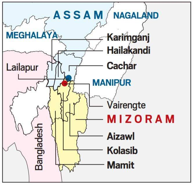
- Mizoram borders Assam’s Barak Valley, and both border Bangladesh.
- The boundary between the two states, which runs 165 km today, has a history dating back to the time when Mizoram was a district of Assam and known as Lushai Hills. Boundary demarcations in 1875 and 1933, particularly the second one, are at the heart of the dispute.

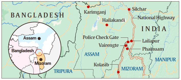
Pic Credit: Indian Express - The 1875 demarcation, notified on August 20 that year, derived from the Bengal Eastern Frontier Regulation (BEFR) Act, 1873.
- It differentiated Lushai Hills from the plains of Cachar in Assam’s Barak Valley.
- This was done in consultation with Mizo chiefs, and it became the basis for the Inner Line Reserve Forest demarcation in the Gazette two years later.
- The 1933 demarcation marks a boundary between Lushai Hills and Manipur, beginning at the tri-junction of Lushai Hills, Cachar district and Manipur. The Mizos do not accept this demarcation on the ground that their chiefs were not consulted this time.
- Vairengte in Mizoram and Lailapur in Assam have seen violence in recent months. Mamit and Mizoram capital Aizawl lie south of Kolasib.
Which is the boundary does Mizoram find acceptable?
- According to Mizo leaders, the only acceptable boundary is the Inner Line of 1875 on the southern frontier of Cachar, notified as per the BEFR Act. (This was subsequently revised in 1878 as it sought to demarcate the Lushai Hills frontier from the plains of Assam.)
Point of contention
- The present so-called boundary was arbitrarily made in 1930 and 1933 without the consent and approval of the competent authorities and the people of the Lushai Hills, now Mizoram, thereby unreasonably excluding some of the Lushai inhabited areas such as Cachar Zion, Tlangnuam, Lala Bazar and Banga Bazar.
- It is to the Mizos no more than an imaginary line pushed farther and farther south of the Inner Line of 1875, depriving the Mizos of the gentle slopes and flat lands for the convenience of outside settlers (mainly Bangladeshees) brought by the British.
- they were referring to a time when the country of Bangladesh had not even been created.
When did the dispute become so bitter?
- The dispute has been simmering since Mizoram became a Union Territory in 1972 and then a state in the 1980s. The two states signed an agreement that status quo should be maintained at no-man’s land set up in the boundaries.
- While alleged transgressions have often happened over the decades, skirmishes have happened very frequently in recent months.
- While Assam sees its claimed boundary as transgressed, Mizoram cites unilateral moves by Assam inside Mizoram territory.
- It alleges that in June last year, Assam officials entered Mamit district and visited some farms; that miscreants entered Kolasib district and burnt down two farm huts; and that Assam officials visited the inter-state border between Vairengte (Mizoram) and Lailapur (Assam) and crossed the duty post manned by the CRPF.
- Mizoram claims that both Assam and Mizoram authorities have undertaken construction work at Buarchep village of Mizoram, and that the Home Ministry is aware of all these issues.
- There have been clashes between villagers of Lailapur and Vairengte, and between residents of Karimganj (Assam) and Mamiut (Mizoram).
What are the other border disputes in the region?
- Assam, which shares its boundary with all other Northeast states — and from which states such as Nagaland, Meghalaya and Mizoram were carved out — has been involved in disputes with several of its neighbours.

- Assam and Nagaland share has a 500-km boundary. Violent conflicts, some leading to deaths, have taken place in several phases since 1965. The Manohar Parrikar Institute for Defence Studies and Analyses published a paper on these clashes in 2008.
- With Arunachal Pradesh, Assam shares an around 800-km boundary. Here, the first clashes were reported in 1992. Each state has accused the other of boundary transgressions and illegal encroachment. These issues are now being heard in the Supreme Court.
Polity Current Affairs for UPSC 2021 : Click Here
