Context
-
Recently, the Union Cabinet approved the funding and implementation of Ken-Betwa River interlinking project.
-
The project will be completed in eight years.
What is the Ken-Betwa River interlinking project?
- It is the first project under the National Perspective Plan for interlinking of rivers.
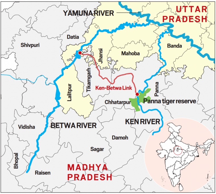
- It envisages transferring water from the Ken river to the Betwa river, both tributaries of the Yamuna.
- The Ken-Betwa Link Canal will be 221 km long, including a 2-km long tunnel.

Credit: IE - The project has two phases, with mainly four components.
- Phase-I will involve one of the components — Daudhan Dam complex and its subsidiary units such as Low Level Tunnel, High Level Tunnel, Ken-Betwa Link Canal and power houses.
- Phase-II will involve three components — Lower Orr Dam, Bina Complex Project and Kotha Barrage.
- According to the Jal Shakti Ministry, the project is expected to provide annual irrigation of 10.62 lakh hectares, supply drinking water to about 62 lakh people, and generate 103 MW of hydropower and 27 MW of solar power.
A Special Purpose Vehicle (SPV) for the project
- According to the statement, a Special Purpose Vehicle (SPV) called Ken-Betwa Link Project Authority (KBLPA) will be set up to implement the project.
- In fact, the Centre has set in motion the process of creation of National Interlinking of Rivers Authority (NIRA), an independent autonomous body for planning, investigation, financing and implementation of the interlinking of river (ILR) projects in the country.
- The NIRA will have powers to set up SPV for individual link projects.
When was the Ken-Betwa River Link Project agreement signed?
- On March 22, 2021, a memorandum of agreement was signed among the Ministry of Jal Shakti and the governments of Madhya Pradesh and Uttar Pradesh to implement the Ken-Betwa Link Project (KBLP).
How was the project conceptualised?
- The idea of linking Ken with Betwa got a major push in August 2005, when a tripartite memorandum of understanding for preparation of a detailed project report (DPR) was signed among the Centre and the two states.
- In 2008, the Centre declared KBLP a National Project. Later, it was included as part of the Prime Minister’s package for development of drought-prone Bundelkhand region.
- In April 2009, it was decided that the DPR will be prepared in two phases. In 2018, a comprehensive DPR including phase-I, II and additional area proposed by Madhya Pradesh was also prepared.
- It was sent to Uttar Pradesh, Madhya Pradesh and the Central Water Commission in October 2018.
- The memorandum of agreement was signed to implement the project.
Which regions will benefit from it?
- The Ken-Betwa River Link Project lies in Bundelkhand, a drought-prone region, which spreads across 13 districts of Uttar Pradesh and Madhya Pradesh.
- According to the Jal Shakti Ministry, the project will be of immense benefit to the water-starved region, especially the districts of Panna, Tikamgarh, Chhatarpur, Sagar, Damoh, Datia, Vidisha, Shivpuri and Raisen of Madhya Pradesh, and Banda, Mahoba, Jhansi and Lalitpur of Uttar Pradesh.
- It will pave the way for more interlinking of river projects to ensure that scarcity of water does not become an inhibitor for development in the country.
Will the project affect the Panna Tiger Reserve?
- According to the National Water Development Agency under the Jal Shakti Ministry, the Daudhan dam, to be built on the Ken river, will be 77 metres high and its gross capacity will be 2,853 million cubic metres.
- According to the NWDA, the reservoir of Daudhan dam will involve “a submergence of 9000 ha area, out of which 5803 ha comes under Panna Tiger Reserve. The later includes 4141 ha of forest area which is about 7.6% of the total Panna Tiger Reserve area”.
- In order to mitigate adverse impacts on Panna Tiger Reserve, as decided by NTCA, Landscape Management Plan to decide mitigation strategy with respect to Ken-Betwa Link entrusted to Wildlife Institute of India, Dehradun and is in its final stage.
- In addition to above three wildlife sanctuaries, viz Nauradehi, Rani Durgawati of MP and Ranipur WLF of UP are planned to be integrated with PTR for proper conservation of Wild Life under Tiger Reserve.
How old is the concept of river linking in India?
- In the past, several river linking projects have been taken up.
- For instance, the Periyar Project, under which transfer of water from Periyar basin to Vaigai basin was envisaged, was commissioned in 1895.
- Other projects such as Parambikulam Aliyar, Kurnool Cudappah Canal, Telugu Ganga Project, and Ravi-Beas-Sutlej too were undertaken.
- In the 1970s, the idea of transferring surplus water from a river to a water-deficit area was mooted by the then Union Irrigation Minister Dr K L Rao. Himself an engineer, he suggested construction of a National Water Grid for transferring water from water-rich areas to water-deficit areas.
- It was not until August 1980 that the Ministry of Irrigation prepared a National Perspective Plan for water resources development envisaging inter-basin water transfer. The NPP comprised two components: Himalayan Rivers Development; and Peninsular Rivers Development.
- For instance, the Periyar Project, under which transfer of water from Periyar basin to Vaigai basin was envisaged, was commissioned in 1895.
- Based on the NPP, the National Water Development Agency (NWDA) identified 30 river links– 16 under Peninsular component and 14 under Himalayan Component.
- Later, the river-linking idea was revived during the Ex- Prime Minister Shri Atal Bihari Vajpayee.
- The Ken-Betwa Link Project is one of the 16 projects under the peninsular component.
What clearances are required for a river linking project?
- Various types of clearances are required, such as:
- techno-economic clearance (given by the Central Water Commission);
- forest clearance and environmental clearance (Ministry of Environment & Forests);
- resettlement and rehabilitation plan of tribal population (Ministry of Tribal Affairs) and
- wildlife clearance (Central Empowered Committee).
Areas of Concern
- Lead to the submergence of a major portion of the core area of the Panna Tiger Reserve in Madhya Pradesh, triggering a major loss of the tiger and its major prey species such as chital and sambar
- May incur an estimated loss of 58.03 square kilometres (10.07 per cent) of critical tiger habitat (CTH) in the reserve.
- An indirect loss of 105.23 sq km of CTH because of habitat fragmentation and loss of connectivity due to submergence
- The project may also lead to a loss of two million trees.
- The land use land cover and vegetation data shows that tree density and diversity are comparatively higher in the submerged area.
- The area that will be submerged due to the KBRIL Project has a rich floral density and diversity.
- Ungulates such as sambar, chital, blue bull and wild boar are the best indicators of good health of a habitat. They are found higher in submerged regions as they prefer moist areas with high vegetation cover.
- The construction of large dams for the interlinking of rivers to solve the irrigation and drinking water problems has created potential threats to faunal as well as floral diversity.
Case Study
- A 2019 NITI Aayog report had mentioned Jakhni village of Banda district in Bundelkhand, one of the most water-scarce regions of India. The area witnessed heavy out-migration in search of water and better livelihood opportunities.
- However, through rigorous water conservation efforts such as the construction of farm ponds, restoration of water bodies, collection and utilization of greywater, raising of farm bunds and intensive plantation of trees since 2014, the water situation has improved. Jakhni village, for example, has become a water self-sufficient village.
Back to Basics
About National River Linking Project (NRLP)
- National River Linking Project (NRLP) also known as the National Perspective Plan aims to link Indian rivers by a network of reservoirs and canals.
- The main objective is to transfer water from water ‘surplus’ basins suffering from floods to water ‘deficit’ basins suffering from drought/scarcity.
- The then Ministry of Irrigation prepared this plan in August 1980.
- The NRLP is managed by National Water Development Agency (NWDA) under the Ministry of Jal Shakti.
- The plan proposes 30 river links to connect 37 rivers across India under two components:
- Under Himalayan Rivers Development Component, 14 river links have been identified.
- Peninsular Rivers Development Component or the Southern Water Grid includes 16 river links. Ken Betwa Link Project is one among them.
Visit Abhiyan PEDIA (One of the Most Followed / Recommended) for UPSC Revisions: Click Here
IAS Abhiyan is now on Telegram: Click on the Below link to Join our Channels to stay Updated
IAS Abhiyan Official: Click Here to Join
For UPSC Mains Value Edition (Facts, Quotes, Best Practices, Case Studies): Click Here to Join
